
Old Madras Road (NH75)
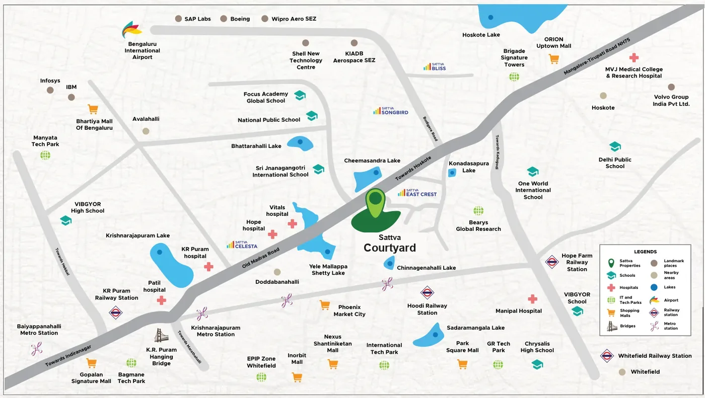
Sattva Courtyard is located on Old Madras Road (NH75) in East Bengaluru — the Bengaluru–Chennai Road, also marked as the Mangalore–Tirupati Road NH75 on the developer's location map. The site sits on the stretch between KR Puram, towards the city to the west, and Hoskote to the east. It is about 300 metres from Cheemasandra Lake, and Budigere Cross is just minutes away. This page explains where the project sits on the corridor, how the plan responds to the highway, and what lies within each approximate distance band.
Quick Facts: Sattva Courtyard on Old Madras Road
| Feature | Key Details |
|---|---|
| Corridor | Old Madras Road (NH75), the Bengaluru–Chennai Road, East Bengaluru. |
| Position on NH75 | Between KR Puram (towards the city, west) and Hoskote (east). |
| Nearest Junction | Budigere Cross, just minutes away. |
| Key Landmark | Cheemasandra Lake, about 300 metres from the site. |
| Nearby Areas (on the developer's map) | Avalahalli, Doddabanahalli, Hoskote and Budigere Road. |
| Highway Planning | Highway buffer zones and acoustic planning for reduced noise. |
| Tech Hubs | Bearys Global Research and Brigade Signature Towers within about 5 km; ITPL, EPIP Zone Whitefield and Bagmane Tech Park approximately 10–15 km. |
| Airport | Kempegowda (Bengaluru) International Airport, approximately 15–25 km. |
| Project Address | Old Madras Road (NH75), near Cheemasandra Lake, East Bengaluru, Karnataka 560049. |
Position on the NH75 Corridor
Old Madras Road (NH75) is the highway that links East Bengaluru with Hoskote and onwards towards Chennai. Sattva Courtyard sits on the stretch between KR Puram, towards the city, and Hoskote, to the east.
- Highway Frontage: The developer's master plan shows the site fronting the Bangalore–Chennai Road (NH-75), marked "Towards Hoskote" in one direction and "Towards K.R. Puram" in the other.
- Budigere Cross: The Budigere Cross junction is just minutes away, and Budigere Road appears on the developer's location map close to the site.
- Access to the City: The developer describes convenient access to KR Puram, Whitefield, key IT hubs, leading schools, malls and Bengaluru International Airport from the site.
Highway Buffer and Acoustic Planning
A highway address brings access, and the plan is designed to keep the highway's noise at a distance from homes:
- Highway Buffer Zones: The developer's plan for this NH75-fronting site includes highway buffer zones.
- Acoustic Planning: Acoustic planning is part of the design, aimed at reduced noise for residents.
- Landscape and Open Space: The master plan legend also lists screen planting, and 80% of the 10-acre site is planned as open space, with about 2 acres of central greens.
- Homes Planned for Light and Air: The apartments are planned with four-sided ventilation and zero shared walls between homes, with light from multiple sides and vertical gardens across levels.
Connectivity from Old Madras Road
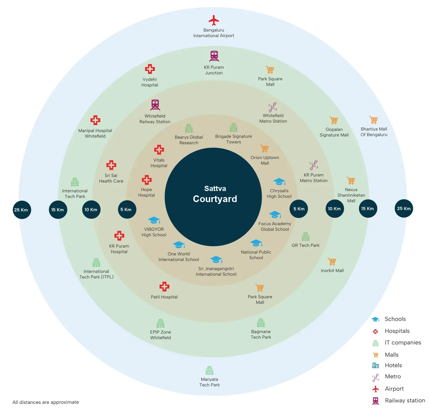
The developer's connectivity map groups nearby destinations into approximate distance bands. All distances are approximate.
- Within about 5 km: Bearys Global Research and Brigade Signature Towers; Vitals Hospital and Hope Hospital; Orion Uptown Mall; and schools including Chrysalis High School, Focus Academy Global School, VIBGYOR High School, One World International School, National Public School and Sri Jnanagangotri International School.
- Approximately 5–10 km: Whitefield Railway Station, Whitefield Metro Station and KR Puram Metro Station; Sri Sai Health Care, KR Puram Hospital and Patil Hospital; Park Square Mall; and GR Tech Park.
- Approximately 10–15 km: KR Puram Railway Junction; Vydehi Hospital and Manipal Hospital Whitefield; International Tech Park (ITPL), EPIP Zone Whitefield and Bagmane Tech Park; and Gopalan Signature Mall, Nexus Shantiniketan Mall and Inorbit Mall.
- Approximately 15–25 km: Kempegowda (Bengaluru) International Airport, Manyata Tech Park and Bhartiya Mall of Bengaluru.
Other Landmarks Along the Corridor
The developer's location map also marks these landmarks around the project. No distances are given for them, so none are quoted here.
- Rail and Metro: Hoodi Railway Station, Hope Farm Railway Station, Krishnarajapuram Metro Station and Baiyappanahalli Metro Station, plus the KR Puram Hanging Bridge.
- Employers and Tech Campuses: Volvo Group India, KIADB Aerospace SEZ, Shell Technology Centre, SAP Labs, Boeing, Wipro Aero SEZ, Infosys and IBM.
- Healthcare, Education and Retail: MVJ Medical College & Research Hospital, Delhi Public School and Phoenix Market City.
FAQs
Sattva Courtyard is on Old Madras Road (NH75), the Bengaluru–Chennai Road in East Bengaluru. The site lies between KR Puram towards the city and Hoskote to the east, about 300 metres from Cheemasandra Lake, with Budigere Cross just minutes away.
On the developer's connectivity map, Whitefield Metro Station and KR Puram Metro Station fall within approximately 5–10 km of the site. All distances are approximate.
The developer's plan includes highway buffer zones and acoustic planning intended to reduce noise from the highway for residents.
Kempegowda (Bengaluru) International Airport falls in the approximately 15–25 km band on the developer's connectivity map, along with Manyata Tech Park and Bhartiya Mall of Bengaluru.
Bearys Global Research and Brigade Signature Towers are within about 5 km. GR Tech Park and Whitefield Railway Station are approximately 5–10 km away, and International Tech Park (ITPL), EPIP Zone Whitefield and Bagmane Tech Park fall in the approximately 10–15 km band. All distances are approximate.